
Gender
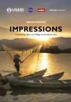
“Impressions” chronicles SERVIR-Mekong's journey from its launch until the present day. The book documents the program's achievements and learnings as SERVIR-Mekong looks to the future—using…

The Earth Science Applications Guidebook is a web-based, multimedia product that synthesizes best practices and lessons learned on the use of Earth science information for decision-making. It is also…
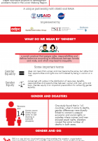
A look at how gender-related issues can be incorporated into Geographic Information Systems (GIS) to support better decision making for climate and disaster risk management and natural resource…
Language:
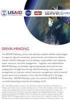
SERVIR-Mekong is a USAID-NASA partnership program designed to improve environmental management and resilience to climate change in the Lower Mekong Region through the increased application of…
The SERVIR-Mekong program’s goal is to enhance climate change adaptation and landscape management in the Lower Mekong sub-region. The program aims to achieve this through the increased application of…
GIS & Geospatial Data
“Impressions” chronicles SERVIR-Mekong's journey from its launch until the present day. The book documents the program's achievements and learnings as SERVIR-Mekong looks to the future—using…
The Earth Science Applications Guidebook is a web-based, multimedia product that synthesizes best practices and lessons learned on the use of Earth science information for decision-making. It is also…
Commodity-Driven Forest Loss: A Study of Southeast Asia represents the culmination of a nearly two-year study funded by the U.S. Agency for International Development’s Regional Development Mission…
Knowledge Products
Commodity-Driven Forest Loss: A Study of Southeast Asia represents the culmination of a nearly two-year study funded by the U.S. Agency for International Development’s Regional Development Mission…

Land cover monitoring efforts are important for resource planning and ecosystem services in many countries. Collect Earth Online (CEO) is a new, free open source and user-friendly software tool for…
Land cover maps play an integral role in environment management. However, countries and institutes encounter many challenges with producing timely, efficient, and temporarily harmonized updates to…
Land cover maps are a critical component to make informed policy, development, planning, and resource management decisions. However, technical, capacity, and institutional challenges inhibit the…
Spatially and temporally consistent vegetation structure time-series have great potential to improve the capacity for national land cover monitoring, to reduce latency and cost of international…
The Mekong region is in the midst of profound social and environmental change. Despite urbanization, the region remains predominantly rural with more than 60 percent of its population living in rural…
Language:
Rapid economic and population growth in the Lower Mekong Region (LMR) – comprising Cambodia, the Lao People’s Democratic Republic, Myanmar, Thailand and Vietnam – continue to drive changes in the…
The SERVIR-Mekong program’s goal is to enhance climate change adaptation and landscape management in the Lower Mekong sub-region. The program aims to achieve this through the increased application of…
Multimedia
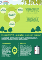
A SERVIR-Mekong infographic: SERVIR-Mekong, funded by USAID, in partnership with NASA, uses a suite of publicly available data from space technology to create innovative solutions to development…
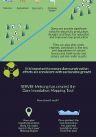
The Dam Inundation Mapping Tool: Millions of people in Southeast Asia rely on the Irrawady, Salween, Mekong and Red Rovers for fishers, agriculture, electricity, and drinking water. This infographic…
A SERVIR-Mekong infographic: SERVIR-Mekong, funded by USAID, in partnership with NASA, uses a suite of publicly available data from space technology to create innovative solutions to development…
The Dam Inundation Mapping Tool: Millions of people in Southeast Asia rely on the Irrawady, Salween, Mekong and Red Rovers for fishers, agriculture, electricity, and drinking water. This infographic…
Shedding new light on land subsidence and sea level rise and facilitating flood early warning
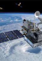
Enhancing our understanding of global weather and climate with precipitation estimates covering much of the planet
Climate change is increasing the frequency and intensity of weather related events…
A look at how gender-related issues can be incorporated into Geographic Information Systems (GIS) to support better decision making for climate and disaster risk management and natural resource…
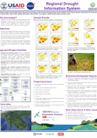
Why this Project?
Droughts in the Lower Mekong Region negatively impact ecosystem services, food and water security and biodiversity. These impacts are exacerbated by climate change, further…
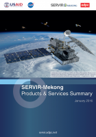
SERVIR-Mekong is a USAID-NASA partnership program designed to improve environmental management and resilience to climate change in the Lower Mekong Region through the increased application of…
Language::
Rapid economic and population growth in the Lower Mekong Region (LMR) – comprising Cambodia, the Lao People’s Democratic Republic, Myanmar, Thailand and Vietnam – continue to drive changes in the…