
3D Participatory Mapping: A Model to Promote Socially-inclusive Climate Action

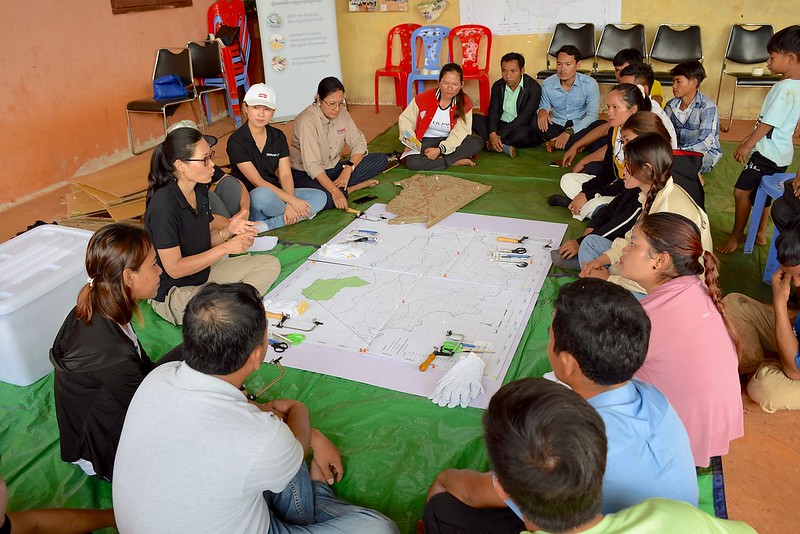
Keo Seima Wildlife Sanctuary, Cambodia – 1 Oct. 2024 – More than 30 members of the youth, elderly, women, village leaders, and local officials this month participated in a 3D participatory mapping exercise that organizers hope could become a model for community-led and socially inclusive climate action planning in Southeast Asia.
By fostering awareness through community engagement, the Building a Participatory 3D Model for Putrom village in Keo Seima Wildlife Sanctuary strengthens local participation in sustainable landscape management and highlights the importance of biodiversity, thus promoting effective conservation as well as long-term economic and agricultural development.
The Keo Seima Wildlife Sanctuary is a REDD+ project led by the Wildlife Conservation Society (WCS) that aims to reduce emission from deforestation and forest degradation while benefiting local communities through sustainable forest management, biodiversity and enhancement of forest carbon stock.
REDD+ refers to a process moderated by the United Nations Framework Convention on Climate Change (UNFCCC) which supports developing countries' efforts to reduce emissions from deforestation and forest degradation, and foster conservation, sustainable management of forests, and enhancement of forest carbon stocks.
While participatory 3D modeling has been implemented in the past, it is the first time that SERVIR Southeast Asia (SERVIR SEA) is partnering with collaborators in the region to combine its geospatial data collection and mapping prowess with community development assets and networks of others.
“SERVIR SEA’s geospatial technology empowers Cambodia through the Biophysical M&E Dashboard, a vital tool for monitoring land use, land cover change and conservation project progress. Participatory 3D mapping is the approach that fosters conservation within wildlife sanctuaries. This collaborative approach promises to increase communities’ engagement and enhance land management practices, paving the way for a resilient Putrom village,” says Nguyen Hanh Quyen, ecosystems and carbon management theme lead at SERVIR SEA.
SERVIR SEA – a joint partnership between the U.S. Agency for International Development (USAID), the U.S. National Aeronautics and Space Administration (NASA), and the Asian Disaster Preparedness Center (ADPC) – uses publicly available satellite imagery and geospatial technologies to address climate change challenges in the region.
With support from USAID/Cambodia, SERVIR SEA works on geospatial applications that inform decision makers and the public on sustainable agriculture, biodiversity conservation, and climate actions, ultimately contributing to decreased greenhouse gas emissions and improving the local communities’ livelihood. USAID/Cambodia Morodok Baitang project and WCS were the main SERVIR SEA partners in this exercise.
“The participatory 3D modeling in Putrom village is an important step in getting the community involved in forest conservation work. WCS aims to empower local communities to take an active role in forest protection. Through 3D mapping exercises, we hope to learn more about the local knowledge and how to wisely protect forest and wildlife. By working together with local communities, we can understand the landscape better to improve the livelihoods of the local community,” says Kimheak Chhay, Community and REDD+ manager for WCS’s Cambodia Program.
The WCS program in Cambodia oversees community engagement work with a primary focus on empowering indigenous communities to exercise their land and natural resource rights and improving the well-being of the communities residing in and around the Keo Seima Wildlife Sanctuary.
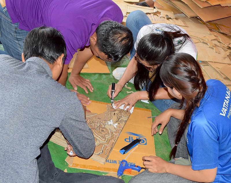
During the first two days of the August workshop, youth teams, with technical assistance from WCS, produced a multi-colored 3D model of the village, with the relevant high-and-low contours. On Day 3, after an introduction on the 3D mapping process and community land management zoning exercise, and in the presence of the village community leaders, the participants engaged in group discussions on marking land boundaries. The discussions helped suggest which land portions could be used better for crop yield or for conservation, and how the exercise can advance knowledge and information sharing on protected area land management.
“I am proud that my village was selected for this 3D mapping exercise. As an expecting mother, I want my child to grow up in a healthy forest and environment. With this 3D map, we can protect our forest better because we can exactly see where the high and low areas are. I am ready to contribute my knowledge and skills to make this map as precise as possible,” said Chruk Sreytis,a 27-year-old female villager and a member of the Green Changemakers Group.
Yoeun Sasvith, member of the Green Changemaker youth group, underlined that “Participating in the 3D mapping exercise transformed my understanding of our landscape. It gave me a more detailed view of areas, which is crucial for planning our conservation efforts. With this new knowledge, I feel more empowered to make decisions and advocate for our community’s needs.”
The participatory 3D exercise in Cambodia has the potential to become a model for sustainable land management, with implications for similar socially inclusive experiments for flood and drought in other parts of Southeast Asia.
SERVIR SEA has already received interest from the Asian Indigenous Peoples Pact in Thailand that the 3D Modeling exercise can be applied in northern parts of the country to address drought and flood issues.
“Conducting 3D mapping exercises with indigenous communities goes beyond just enhancing understanding of local landscapes—it’s about amplifying the voices of those who are often marginalized,” said Chinaporn Meechaiya, SERVIR SEA lead for gender equality and social inclusion.
“By integrating this participatory approach, we are not only improving planning and management but also ensuring that diverse perspectives are at the forefront of climate adaptation efforts. This approach not only raises awareness but also empowers communities to act on climate information, making it a vital tool for inclusive and effective environmental stewardship,” she added.