
From Space to Village: Geospatial Technology and Artificial Intelligence Provide Unique Opportunities to Transform Forest Conservation in Cambodia.
Monitoring forest loss remotely is needed for formulating policies and strategies to address deforestation. Currently, rangers spend long periods of time patrolling forests to monitor forest health and checking for illegal logging and land clearances. Thanks to technological advances that have improved their accuracy and lowered costs, the use of geospatial technology and artificial intelligence has proven to be an effective alternative to combating illegal logging and land clearance and can now identify these disturbances in near-real time.
Cambodia has grappled with deforestation for many years. Cambodia experienced a significant reduction in forest cover from 73.4 percent in 1965 to 46.86 percent in 2018. Deforestation and forest degradation release vast amounts of greenhouse gases into the atmosphere, lead to biodiversity loss, reduce water quantity and quality, and adversely impact the livelihoods of local communities and indigenous people.
Forest Cover Change in Cambodia 1965 - 2018
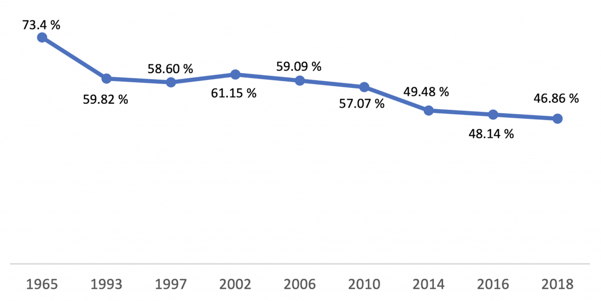
Source: Ministry of Environment, Government of Cambodia
A recent USAID-funded report on Commodity-driven Forest Loss in Southeast Asia found that the primary drivers of deforestation in Cambodia are legal and illegal logging, charcoal production, mining, and economic land concessions for commodity crop plantations.
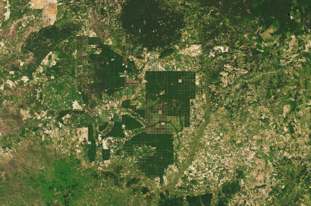
The Prey Lang Extended Landscape is a region in Cambodia where these drivers are very visible, challenging the implementation of USAID’s Greening Prey Lang project, which aims to promote resilient, low-emission, and inclusive, sustainable management of this area of Cambodia. The Prey Lang Extended Landscape covers approximately 3.5 million hectares of forests, watersheds, and agricultural land across four provinces (Kampong Thom, Preah Vihear, Stung Treng, and Kratie) in Cambodia. It is home to more than 1 million people, numerous protected areas, United Nations Educational, Scientific and Cultural Organization (UNESCO) world heritage sites, and dozens of endangered animal and plant species.
There are several challenges facing the successful implementation of this project including continued illegal timber trade across the country’s porous borders, extensive land clearance, poor law enforcement, and lack of good governance systems. According to Matthew Edwardsen, Chief of Party for USAID Greening Prey Lang, “Discussions around deforestation in Cambodia tend to focus on the illegal timber trade, which, while an extremely serious problem, it is not the greatest cause of forest loss. What we are seeing is widespread illegal forest clearance for agriculture that is driven by land speculation. Early identification of these clearings and permanent expulsion of illegal farmers from them must occur if we want to see a decrease in the deforestation trends in the protected areas where we are working. ”
SERVIR-Mekong, a regional initiative of USAID and NASA, in collaboration with the Applied Science Team from Oregon State University has teamed up with USAID Greening Prey Lang to address some of these problems by developing the Cambodia Protected Area Alerts System. This system monitors near real-time forest changes and external threats such as forest fires within the Prey Lang Extended Landscape. The Cambodia Protected Area Alerts System is a key component of the Protected Area Monitoring Platform, launched recently by Cambodia’s Ministry of Environment, which integrates ground-based and remotely sensed data to improve the efficiency and effectiveness of law enforcement and conservation activities.
Phase one of the Cambodia Protected Area Alerts System, shown in Figure 1, is configured to use forest disturbance alerts published by the Global Land Analysis and Discovery (GLAD) program of the University of Maryland. GLAD alerts are then paired with high resolution satellite imagery from the European Space Agency (ESA) Copernicus Sentinel-2 satellites. Trained analysts then verify the accuracy of alerts prior to initiating a ground response.
Screenshots from the Phase One Cambodia Protected Area Alert System
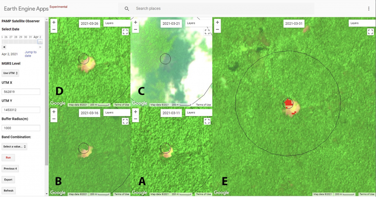
Figure 1. The figure above shows five optical images from Cambodia’s Prey Lang Wildlife Sanctuary captured by the Sentinel-2 satellite. Image A is from March 11, 2021 and Image E is from March 31, 2021. Images B through D are captured in five day intervals during the date range above. Images A and B show a small clearing of forest that is expanding. Image C is obscured by cloud shadow. Image D shows that the clearing has continued to expand. Image E highlights the GLAD Forest Alert location in red. Deployment of a forest ranger patrol when Image A was detected would have prevented this part of Prey Lang Wildlife Sanctuary from being permanently converted from forest to an agricultural field.
The first phase of the Cambodia Protected Area Alerts System uses non-cloud cover penetrating optical imagery for forest monitoring. However, Cambodia experiences a long rainy season for over half of the year with extended periods of persistent cloud cover. This causes significant interruptions in the frequency of forest alerts coming from the GLAD system. To tackle this problem, SERVIR Mekong looked to Synthetic Aperture Radar (SAR) technology, which is also provided by the ESA Copernicus program through their Sentinel 1 SAR satellites. This radar technology is cloud penetrating and images the Earth’s surface at reliable intervals throughout the year, rain or shine. Methods to generate forest disturbance alerts using SAR are not available for public use, so SERVIR Mekong built an interface as noted in Figure 2.
Currently in the second, and final phase of development, the SAR interface of the Cambodia Protected Area Alerts System has been built on a cloud-based platform which uses artificial intelligence and satellite-based observations via the Google Earth Engine. The System also uses Collect Earth Online to access multiple satellite platforms and improve imagery displays. Once disturbances in an area are detected by the computer algorithms that scan and analyze satellite images, ground patrol units can be dispatched to the affected areas to address, and ideally reverse, the cause of deforestation. Verification of alerts by ground patrols provides the artificial intelligence embedded within the system the data required for machine learning to occur. Overtime, the accuracy of alerts will be improved through machine learning, which will ensure ground patrols are dispatched as efficiently as possible.
Screenshots from Phase Two of Cambodia Protected Area Alert System
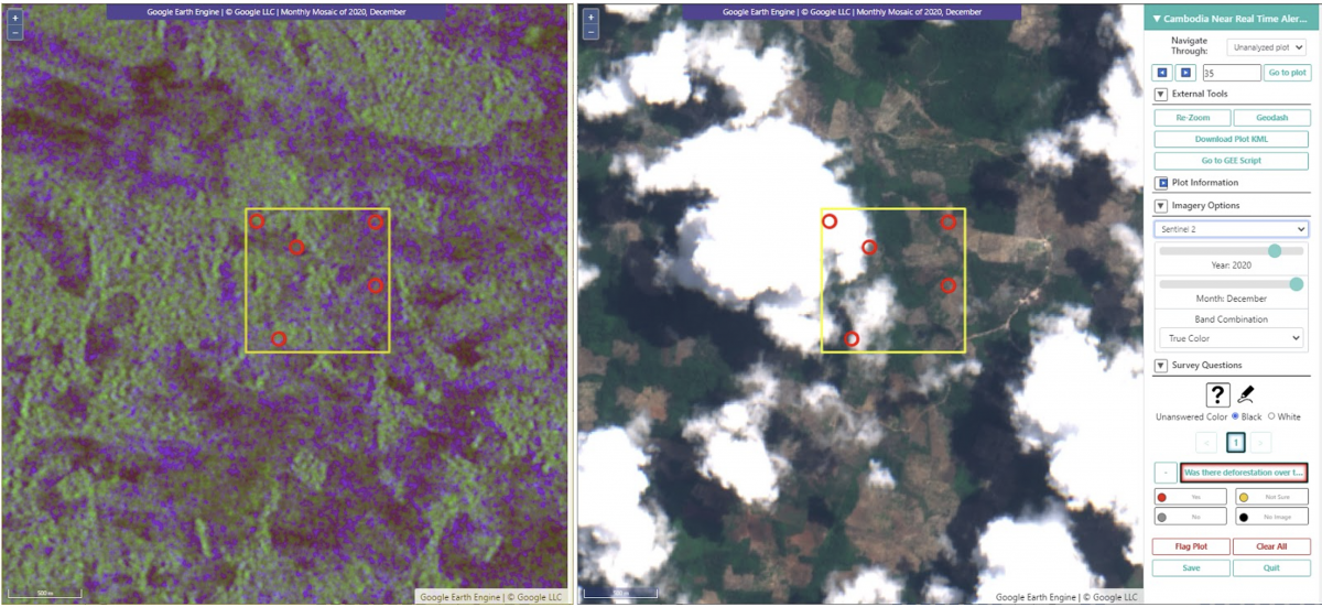
Figure 2. The image above shows side-by-side windows with Sentinel-1 SAR on left and Sentinel-2 optical imagery on right for the same location in Cambodia’s Prey Lang Wildlife Sanctuary in December 2020. The SAR imagery is not as visually clear to the human eye, but the cloud penetrating capacity of SAR is vital for an effective forest disturbance alert response system. The red circles are SAR-based alert locations within a 1km plot as illustrated by the yellow box.
Once fully operational, the Cambodia Protected Area Forest Alert System will equip the Cambodian Ministry of Environment with “eyes in the sky” that will enable them to remotely monitor an area of 3.5 million hectares from their desktops. The effectiveness of this technology depends on multiple factors. Close and timely coordination among all the relevant stakeholders is critical. Deforestation alerts generated by the system must be investigated and addressed by authorities per the Protected Area Monitoring Platform’s standard operating procedures. If deforestation alerts are not investigated and addressed then these technological innovations will not result in improved forest protection.
The system also provides verifiable, transparent, and accountable site-specific information to support Cambodia’s national forest monitoring programs. This is required in order to attract sustainable financing for Cambodian conservation and carbon credit investments. According to Ecosystem Marketplace, Cambodia has already raised over $11 million for forest conservation from international companies in Europe, Japan, and the United States. An Asian Development Bank Study estimated the market for avoided deforestation in Cambodia at $316 million between 2015 and 2020. This number is only going to expand in the future as carbon prices stabilize and increase. Furthermore, as a signatory to the United Nations Framework Convention on Climate Change (UNFCCC) Cambodia has supported the development of REDD+ and has an ambitious target to reduce its annual deforestation in half by 2026, with 2006 serving as the base year. As the REDD+ market expands across Cambodia, the Cambodia Protected Area Forest Alert System can be used to monitor and address illegal logging and land clearance. Together with SERVIR-Mekong’s Biophysical M&E Dashboard - a tool that monitors the performance of landscape-scale efforts and biophysical conditions, both tools can be used to monitor forest cover change and provide a robust platform to evaluate the performance of REDD+ in Cambodia.