
Land and Agriculture Monitoring Project (LAMP)
SERVIR Southeast Asia developed the Land and Agriculture Monitoring Project (LAMP) tool in response to a need expressed by stakeholders, who require insight and reports on the effectiveness of biodiversity and conservation-related project interventions. LAMP is an open-access, web-based tool designed to monitor the landscape and biophysical conditions in Myanmar. The core features of this tool include maps, charts, and descriptive information to track various environmental parameters critical to environmental protection and safeguarding. This user manual provides guidance on how to navigate and effectively utilize the dashboard's features.

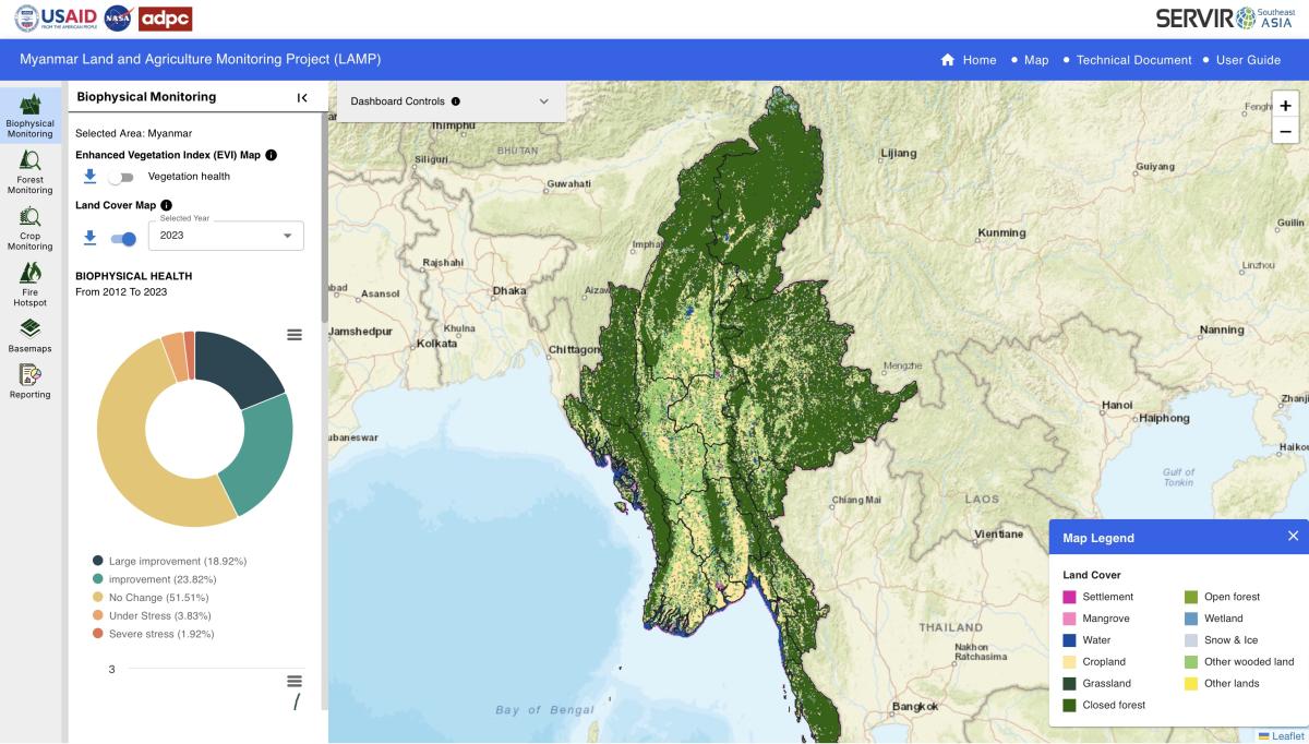
The Land and Agriculture Monitoring Project (LAMP) tool replicates the SERVIR SEA’s Cambodia Biophysical Monitoring and Evaluation Dashboard platform and consists of four key components. The default ‘biophysical monitoring’ layer evaluates changes in broad-scale biological productivity using the Enhanced Vegetation Index (EVI), a measure of relative biomass particularly suited to high-biomass areas of the globe, derived from MODIS multispectral data. The other three components are: forest monitoring (forest gain/loss, derived from Landsat); crop monitoring with seasonal rice cultivation area in the 11 rice production regions/states in Myanmar; and fire monitoring (hotspots and burned area, derived from MODIS). The user interface leverages the power of Google Earth Engine (GEE), a cloud computing platform that links extensive data archives with substantial processing power. With the continuous time-series feature, the user can select a baseline and evaluation period for each of the components as well as an identified area of interest which allows for easy comparisons between ‘before’ and ‘after’ intervention timeframes. The results can be exported in report-style format enabling decision-makers and non-technical users alike to directly use this analysis and information.
Application Purpose
Aside from monitoring the performance of landscape-scale efforts and biophysical conditions on the ground, the Land and Agriculture Monitoring Project (LAMP) tool can provide valuable insights into the possible drivers of change such as climate change, urban expansion, and infrastructure development.
![]() Check this tool out
Check this tool out ![]() https://myanmar-me-servir.adpc.net
https://myanmar-me-servir.adpc.net
Watch a DEMO video ![]() https://bit.ly/3MBHgEK
https://bit.ly/3MBHgEK
Read more ![]() https://bit.ly/3TmvqST
https://bit.ly/3TmvqST
Application Uses
USAID/Burma currently uses the Land and Agriculture Monitoring Project (LAMP) tool to monitor the performance of landscape-scale efforts and biophysical conditions on the ground and monitor the change of the landscape and rice cultivation on the ground for food security purposes in Myanmar.

USAID/Burma
This tool allows users to visualize, explore, and export maps and charts for informed decision-making. It is intended for use by decision-makers, environmental activists, policymakers, NGOs, donors, government ocials, and other stakeholders.
MODIS
Landsat
Sentinel
FIRMS
GLAD
VIIRS