
Featured Technology
The Earth Science Applications Guidebook is a web-based, multimedia product that synthesizes best practices and lessons learned on the use of Earth science information for decision-making. It is also…
Food Security
The Earth Science Applications Guidebook is a web-based, multimedia product that synthesizes best practices and lessons learned on the use of Earth science information for decision-making. It is also…
Gender
The Earth Science Applications Guidebook is a web-based, multimedia product that synthesizes best practices and lessons learned on the use of Earth science information for decision-making. It is also…
The SERVIR-Mekong program’s goal is to enhance climate change adaptation and landscape management in the Lower Mekong sub-region. The program aims to achieve this through the increased application of…
GIS & Geospatial Data
Commodity-Driven Forest Loss: A Study of Southeast Asia represents the culmination of a nearly two-year study funded by the U.S. Agency for International Development’s Regional Development Mission…
The Earth Science Applications Guidebook is a web-based, multimedia product that synthesizes best practices and lessons learned on the use of Earth science information for decision-making. It is also…
Language:
ການຂະຫຍາຍຕົວທາງເສດຖະກິດ ແລະ ປະຊາກອນຢູ່າງໄວວາຢຼູູ່ພາກພ ື້ນແມູ່ນໍື້າຂອງຕອນລ ູ່ມທ ູ່ກວມເອົາປະເທດກໍາປຼູເຈຍ, ສາທາລະນະລັດ ປະຊາທິປະໄຕ ປະຊາຊົນລາວ, ມຽນມາ, ໄທ ແລະ ຫວຽດນາມ ໄດື້ສ ບຕໍູ່ຜັກດັນໃຫື້ມ ການປູ່ຽນແປງ…
The SERVIR-Mekong program’s goal is to enhance climate change adaptation and landscape management in the Lower Mekong sub-region. The program aims to achieve this through the increased application of…
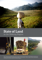
The Mekong region is in the midst of profound social and environmental change. Despite urbanization, the region remains predominantly rural with more than 60 percent of its population living in rural…
Land Cover / Land Use & Ecosystems

Land cover monitoring efforts are important for resource planning and ecosystem services in many countries. Collect Earth Online (CEO) is a new, free open source and user-friendly software tool for…
Regional
The Earth Science Applications Guidebook is a web-based, multimedia product that synthesizes best practices and lessons learned on the use of Earth science information for decision-making. It is also…
Commodity-Driven Forest Loss: A Study of Southeast Asia represents the culmination of a nearly two-year study funded by the U.S. Agency for International Development’s Regional Development Mission…
Land cover monitoring efforts are important for resource planning and ecosystem services in many countries. Collect Earth Online (CEO) is a new, free open source and user-friendly software tool for…
Land cover maps are a critical component to make informed policy, development, planning, and resource management decisions. However, technical, capacity, and institutional challenges inhibit the…
Land cover maps play an integral role in environment management. However, countries and institutes encounter many challenges with producing timely, efficient, and temporarily harmonized updates to…
Spatially and temporally consistent vegetation structure time-series have great potential to improve the capacity for national land cover monitoring, to reduce latency and cost of international…
The Mekong region is in the midst of profound social and environmental change. Despite urbanization, the region remains predominantly rural with more than 60 percent of its population living in rural…
Language:
ການຂະຫຍາຍຕົວທາງເສດຖະກິດ ແລະ ປະຊາກອນຢູ່າງໄວວາຢຼູູ່ພາກພ ື້ນແມູ່ນໍື້າຂອງຕອນລ ູ່ມທ ູ່ກວມເອົາປະເທດກໍາປຼູເຈຍ, ສາທາລະນະລັດ ປະຊາທິປະໄຕ ປະຊາຊົນລາວ, ມຽນມາ, ໄທ ແລະ ຫວຽດນາມ ໄດື້ສ ບຕໍູ່ຜັກດັນໃຫື້ມ ການປູ່ຽນແປງ…
The SERVIR-Mekong program’s goal is to enhance climate change adaptation and landscape management in the Lower Mekong sub-region. The program aims to achieve this through the increased application of…
Vietnam
Land cover change and its impact on food security is a topic that has major implications for development in population-dense Southeast Asia. The main drivers of forest loss include the expansion of…
The Earth Science Applications Guidebook is a web-based, multimedia product that synthesizes best practices and lessons learned on the use…
Commodity-Driven Forest Loss: A Study of Southeast Asia represents the culmination of a nearly two-year study funded by the U.S. Agency for International Development’s Regional…
Land cover maps are a critical component to make informed policy, development, planning, and resource management decisions. However, technical, capacity, and institutional challenges inhibit the…
Land cover maps play an integral role in environment management. However, countries and institutes encounter many challenges with producing timely, efficient, and temporarily harmonized updates to…
Spatially and temporally consistent vegetation structure time-series have great potential to improve the capacity for national land cover monitoring, to reduce latency and cost of international…
Land cover monitoring efforts are important for resource planning and ecosystem services in many countries. Collect Earth Online (CEO) is a new, free open source and user-friendly software tool…
Land cover change and its impact on food security is a topic that has major implications for development in population-dense Southeast Asia. The main drivers of forest loss include the expansion…
The Mekong region is in the midst of profound social and environmental change. Despite urbanization, the region remains predominantly rural with more than 60 percent of its population living in…
Language:
ການຂະຫຍາຍຕົວທາງເສດຖະກິດ ແລະ ປະຊາກອນຢູ່າງໄວວາຢຼູູ່ພາກພ ື້ນແມູ່ນໍື້າຂອງຕອນລ ູ່ມທ ູ່ກວມເອົາປະເທດກໍາປຼູເຈຍ, ສາທາລະນະລັດ ປະຊາທິປະໄຕ ປະຊາຊົນລາວ, ມຽນມາ, ໄທ ແລະ ຫວຽດນາມ ໄດື້ສ ບຕໍູ່ຜັກດັນໃຫື້ມ ການປູ່ຽນແປງ…
The SERVIR-Mekong program’s goal is to enhance climate change adaptation and landscape management in the Lower Mekong sub-region. The program aims to achieve this through the increased application…