
USAID’s SERVIR-Mekong and Google Partnership Enhances Climate Change Adaptation in the Lower Mekong
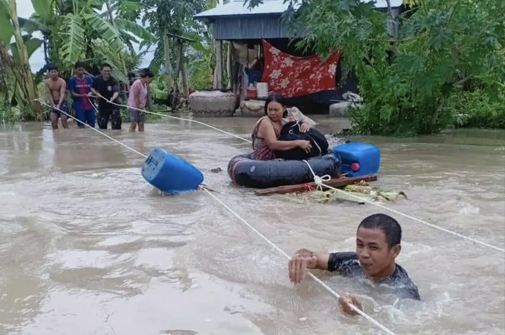
In October 2020, extensive flooding in Cambodia affected over 790,000 people. SERVIR-Mekong, a partnership between the U.S. Agency for International Development (USAID) and the U.S. National Aeronautics and Space Administration (NASA), used Google Earth Engine (GEE) to harness the power of satellite technology to strengthen the disaster response. SERVIR-Mekong provided daily flood extent data for the World Food Programme (WFP) to integrate into their comprehensive disaster risk management platform (Platform for Real-Time Impact and Situation Monitoring – PRISM) in Cambodia. SERVIR-Mekong’s access to satellite data enabled WFP to produce timely and accurate flood map products and situation reports needed to inform the Government and humanitarian partners and produce a series of situation reports. Prior to SERVIR-Mekong’s involvement, access to near real-time flood data to measure the extent of damage was not available.
Mr. Kurt Burja, Programme Policy Officer at WFP commented on the success of this two-year collaboration with the Asian Disaster Preparedness Center (ADPC) and SERVIR-Mekong. “When the large-scale floods hit Cambodia last October, we were quickly able to get flood extent maps”, says Mr. Burja. “This enabled the Cambodian government, WFP and humanitarian partners to better understand the geographical extent of the floods and provide emergency assistance where it was most needed.” This SERVIR-Mekong-WFP collaboration has also been acknowledged by the World Meteorological Organization in its 2020 State of Climate Services report.
This work highlights how engaging the private sector can leverage greater impacts on the ground. SERVIR-Mekong’s partnership with Google has resulted in the application of cutting-edge technologies for climate change adaptation and humanitarian response.The Google Earth Outreach Team provided SERVIR-Mekong with cloud computing resources to utilize the GEE platform in addition to generous training and technical support.
SERVIR-Mekong uses publicly available satellite data to improve development outcomes; to help address environmental and development challenges related to a changing climate. Implemented by the Asian Disaster Preparedness Center, SERVIR-Mekong champions the use of state-of-the-art geospatial technologies to support and enable decision making by governments of the Lower Mekong countries.
SERVIR-Mekong uses GEE to develop and deploy many of its decision-support tools and services including drought monitoring and forecasting, environmental management and water resource management. Once a tool is developed for the Lower Mekong region, it can be expanded across SERVIR’s global network or be scaled down to address a country’s specific needs.
Google Earth Engine is a cloud based geospatial data processing and analysis platform powered by Google’s data center infrastructure. It maintains a detailed catalogue of satellite imagery and geospatial data and makes it available for scientists, researchers, and developers to detect changes, map trends, and quantify differences on the Earth's surface without downloading and managing all the data, rapidly improving the rate of discovery. GEE has been used to monitor global forest change, global surface water detection, disease risk mapping, earthquake damage estimation, and crop yield estimation.
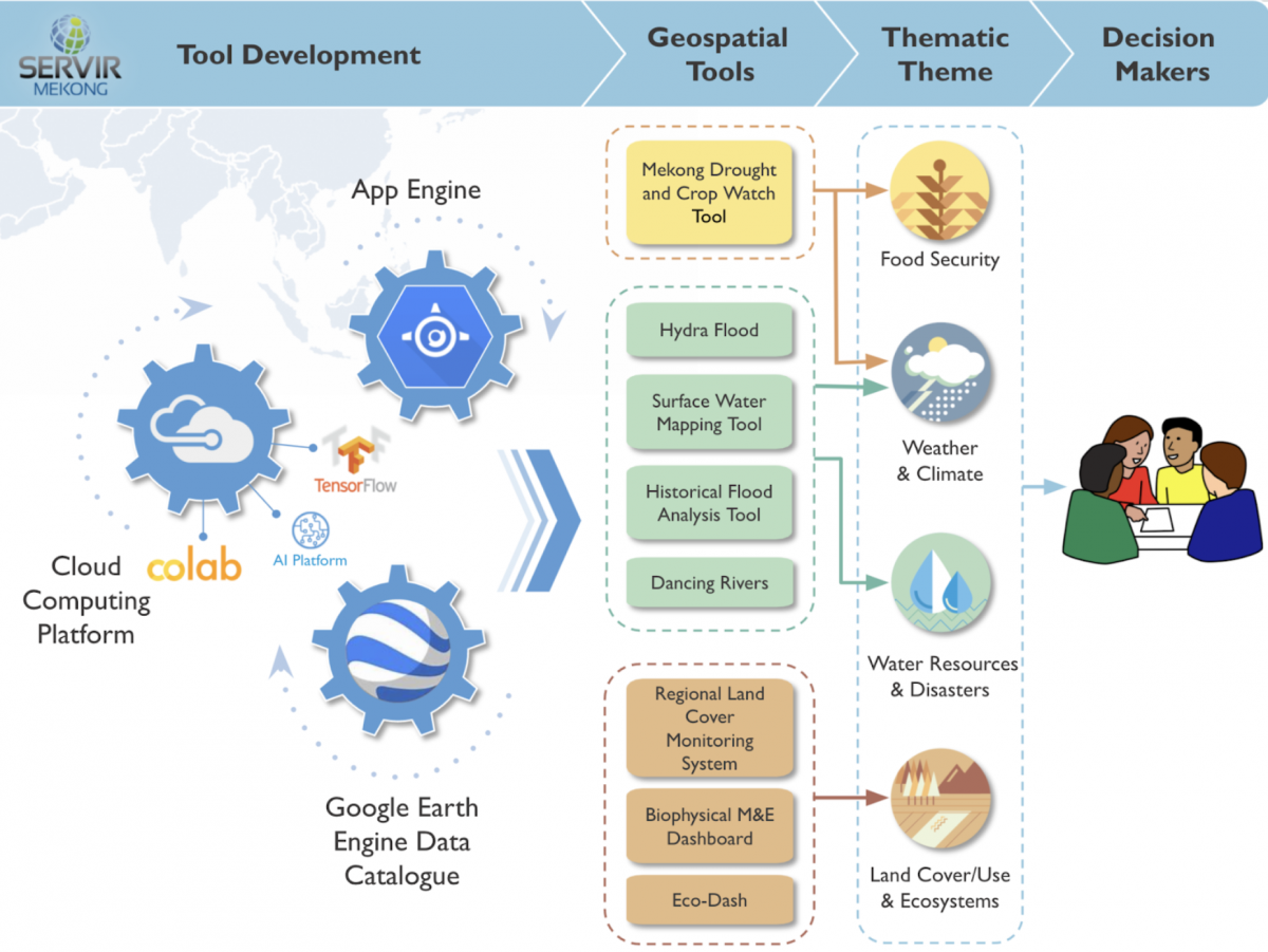
SERVIR-Mekong also incorporates the latest Machine Learning (ML) techniques into its decision-support tools and services through the use of TensorFlow - an end-to-end open source platform for machine learning. TensorFlow has a comprehensive, flexible ecosystem of tools, libraries, and community resources that lets researchers push the state-of-the-art in ML and developers easily build and deploy ML-powered applications.
Conceptualizing, developing, and implementing SERVIR-Mekong’s decision-support tools and services is a demand-driven, iterative process involving active participation from potential users including local and national governments as well as international organizations. The development gains associated with implementing these tools and services take time to materialize. The success achieved using GEE and the Google Cloud Platform’s Artificial Intelligence (AI) platform is encouraging.
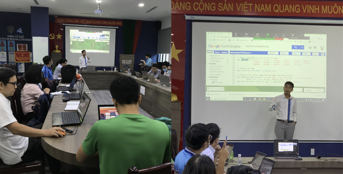
SERVIR-Mekong collaborates with the Google Earth Engine Outreach Team to provide GEE training to the users of the decision-support tools and services to ensure that the technical expertise is transferred to the host countries. Since 2016, a series of eleven training programs have been conducted on the use of GEE for over 450 participants. Beneficiaries of these training programs include the International Union for Conservation of Nature, Vietnam Forest Inventory and Planning Institute, Vietnam Academy of Water Resource and Vietnam Space Technology Institute.
GEE has enabled SERVIR-Mekong’s collaborators to save time and money as they do not need high capacity hard drives and processors to store and process data. “Given that the GEE platform takes advantage of Google’s cloud server capacity to accelerate computing speed, I can now run several case studies for trial and error in my research within minutes and avoid repetition in downloading data, saving and deleting unnecessary outputs” says Mr. Luong Tuan Trung, a researcher at the Vietnam Academy for Water Resources.
Use of geospatial technology in climate adaptation and environmental management has grown exponentially over the years and it will continue to provide innovative ways of collecting and analyzing data; applying the learning to inform future decision making. The proliferation of newer technologies like better satellite sensors, higher internet speeds, cloud computing, and adoption of 5G will accelerate this trend further. SERVIR-Mekong’s partnership with Google continues to leverage cutting-edge technologies to help USAID address climate change in the Lower Mekong region. Larger and better quality data will be critical in solving the environmental problems of tomorrow.